10 square area |
Post Reply 
|
| Author | |
Viror 
New Poster 
Joined: 09 Feb 2021 Location: Italy Status: Offline Points: 22 |
 Post Options Post Options
") Thanks(1) Thanks(1)
 Quote Reply Quote Reply
 Topic: 10 square area Topic: 10 square areaPosted: 07 Aug 2024 at 16:59 |
|
Hello, since a lot of things revolve around the 10 squares around a city, i was thinking it would be really useful to add an option to the regional map that can turn on/off a visible 10 square area around cities, maybe with the additional option of being able to choose whether to see the 10 squares around allied, neutral or enemy cities. Being able to actually see this area on the map would be very useful for both hunting/gathering and strategic purposes.
|
|
 |
|
|
Ordo
Wordsmith 

Joined: 31 Mar 2022 Location: Elgea Status: Offline Points: 130 |
Post Options
Thanks(0)
Quote Reply
Posted: 07 Aug 2024 at 23:00 |
|
Just switch on "sovereignty" on the tactical map, or set your alliance as green, and two others as red and blue on the strategic map, those possibilities are already there.
|
|
|
|
|
Smopecakes
Forum Warrior
Joined: 14 Apr 2017 Status: Offline Points: 335 |
Post Options
Thanks(1)
Quote Reply
Posted: 08 Aug 2024 at 02:14 |
|
Sov is only the claimed area, a 10 sq radius would be different and super handy. Someone poke Baz or Tens...
|
|
|
|
|
Viror
New Poster
Joined: 09 Feb 2021 Location: Italy Status: Offline Points: 22 |
Post Options
Thanks(1)
Quote Reply
Posted: 08 Aug 2024 at 08:12 |
Soveregnity is a completely different thing and depends on how many squares a player wants to claim, in the tactical map there is no possibility of seeing an area of 10 squares around the cities, and it would also be very difficult to see it from there. I mean seeing an area or a perimeter of 10 squares around the cities in tactical map, of a different color in the case of allies, neutrals or enemies. It is a suggestion without any malus side but it is simply a useful additional option that is given to players, if the devs team can do it of course, I don't know if it would be too complicated to do.
|
|
|
|
|
Tensmoor
Postmaster General 

Joined: 07 Apr 2015 Location: Scotland Status: Offline Points: 1897 |
Post Options
Thanks(0)
Quote Reply
Posted: 08 Aug 2024 at 13:40 |
|
The images for the strategic map are static generated images. As such it is feasible to generate one on the fly but I'm not sure how much server resources it would take. You would need access to the coords and ownership of every town, the relationships between your alliance and every other and then go through all that building the map. It certainly would take a reasonable amount of resources on the servers I use. No idea about the ones the devs use. Tens
|
|
|
|
|
Thirion
Postmaster 
Joined: 10 Apr 2018 Status: Offline Points: 680 |
Post Options
Thanks(1)
Quote Reply
Posted: 08 Aug 2024 at 13:58 |
|
In my opinion this feature would be amazing - as it is currently hard to see what is inside/outside the cities 10 square range or not. How it would look like (sorry for my bad Paint skills): 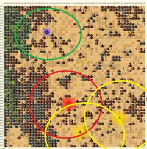 |
|
|
|
|
Ordo
Wordsmith
Joined: 31 Mar 2022 Location: Elgea Status: Offline Points: 130 |
Post Options
Thanks(0)
Quote Reply
Posted: 08 Aug 2024 at 14:50 |
|
OK it would really add something, the visualisation really helps. I support the idea.
Edited by Ordo - 08 Aug 2024 at 14:51 |
|
|
|
|
Tensmoor
Postmaster General
Joined: 07 Apr 2015 Location: Scotland Status: Offline Points: 1897 |
Post Options
Thanks(0)
Quote Reply
Posted: 08 Aug 2024 at 14:54 |
|
So a modification to the map overlay tool to allow different colours for friendly, neutral and hostile towns... I'll have a look at it. Tens
|
|
|
|
|
Post Reply
|
|
 Tweet
Tweet
|
| Forum Jump | Forum Permissions You cannot post new topics in this forum You cannot reply to topics in this forum You cannot delete your posts in this forum You cannot edit your posts in this forum You cannot create polls in this forum You cannot vote in polls in this forum |


 Topic Options
 Ordo wrote: